Written By NCSG Graduate Assistants Finn Meggitt & Cole Shultz

Figure 1: Multifamily Housing Construction in College Park by Number of Units and Year Structure Built from 2000-2025. Source: Prince George’s County Build Permit Data
Introduction:
Drive down Maryland State Route 1 today and you’ll find a very different College Park than from 20 years ago, with a skyline dominated by new multifamily projects shown in Figures 1 and 2. This change is an intentional response to an increasing student population and demand for more housing, better multimodal access, and an enhanced sense of place. The 2010 Central US 1 Corridor Sector Plan facilitated this transformation, but the demand for new housing preceded this policy, and other actors, especially the University of Maryland-College Park (UMD), are deeply connected to this process.
UMD in particular has realized the benefits of new housing, transportation options, and amenities near campus. These changes foster a stronger sense of community, advance sustainability goals, and represent a clear break from the UMD of the past which opposed Metro access on the Green Line and built no new dorms between 1982 and 2011. UMD has also worked to improve the town/gown relationship with the City of College Park, resulting in the Greater College Park Initiative. This has resulted in $2+ billion worth of public-private investments and contributed to the development of over 30 residential and commercial real estate projects. Likewise, the City of College Park has approved over 3,000 new housing units since the initiative was announced, expanding housing access. Highlights of this program include the Union on Knox apartment buildings, with over 796 beds available for rent, the creation of the Discovery District as a globally competitive mixed-use research hub, and a development delivering a new City Hall for College Park alongside offices, retail and a public plaza. Discovery House is another new multifamily development, replacing 220 units of townhomes with fully-furnished units that will house 800 graduate students.
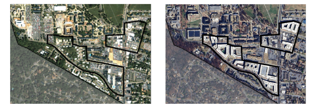
Figure 2: Aerials of South Baltimore Ave May, 2001 (left) and May, 2025 (right).
The City of College Park is also a major actor in this process, as it has designed policies to spur multifamily construction while minimizing the conversion of single-family homes into student rentals. Since 2010, the City has established a rule of no more than five unrelated persons residing within a single-family home, began inspecting every rental single-family unit, and gave property tax abatements to multifamily housing along the Baltimore Avenue corridor. The net result of these changes has been a rapid increase in the number of high-density housing units (Figure 3).
However, this process is not unique to College Park, nor has it come without risks for marginalized communities. These changes occurring in College Park are consistent with two threads of urban planning research: Smart Growth and Studentification. Smart growth principles focus on building connected, service rich communities that serve a broad range of residents. ‘Studentification’, a term coined by Darren P. Smith in 2004 describes “the distinct social, cultural, economic, and physical transformations within university towns”. Studentification can manifest in various ways, including the conversion of single family homes into shared rentals, higher housing costs, crowded parking, poor landscaping and property maintenance practices, and a reorientation of the commercial landscape to cater towards student tastes.
Previous research has also described four main ways in which municipalities can respond to studentification, which include restriction, diversion, intensification, and limited-intervention.
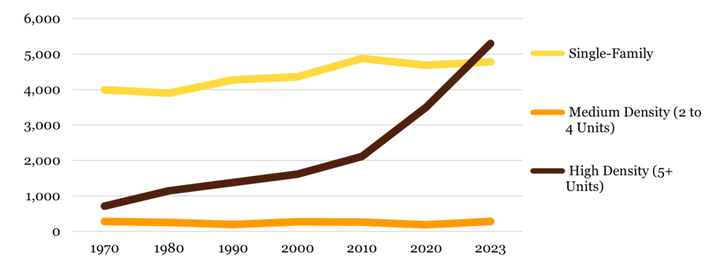
Figure 3: Number of Units by Structure Type. Source: IPUMS NHGIS.
We find that College Park is pursuing diversion and intensification strategies, which has successfully supported a larger student population in College Park. This approach is well-designed in accordance with smart growth principles, as development has been directed towards Route 1 near campus, where there is existing demand, reducing the number of students who need to drive and preserving other nearby low- and moderate-income neighborhoods.
Prior Research Review
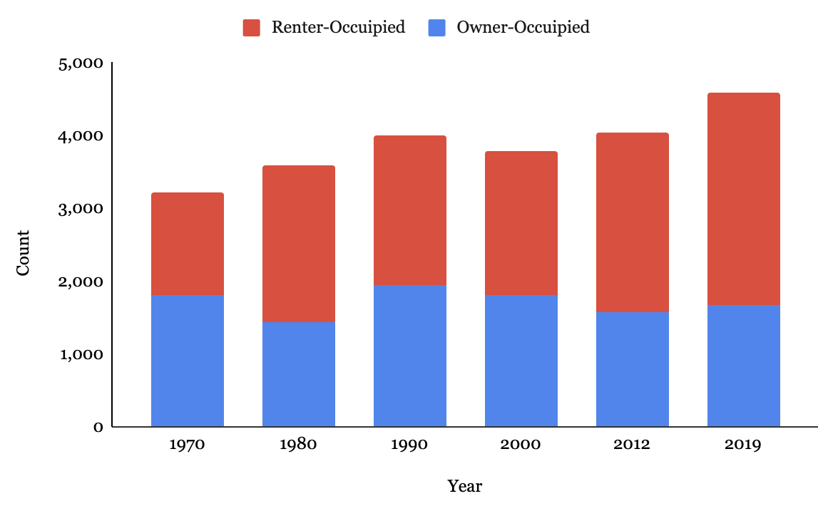
Last year, we undertook the first analysis of student housing patterns at UMD, using anonymous data from UMD’s Office of the Registrar and historical census data. This research forms the basis for our understanding of College Park as a College Town already experiencing studentification. The amount of owner-occupied housing has fallen in both relative and absolute terms from 1980 to 2023, (Figure 4). This decline represents a key indicator of studentification, and matches well with our findings that over 40% of students live within a half-mile of campus.

Figure 4: Tenure by Decade in College Park. Source: Brown University Longitudinal Tract Database analysis of 1970-2000 full count and sample data decennial censuses, and 2008-2012, 2015-2019, and 2018-2023 ACS Data (Logan et al. 2023).
Second, we found that the rail transit-accessibility of UMD will increase by nearly 650% following the completion of the Purple Line, as students living in Hyattsville, Greenbelt, and Silver Spring will have direct access to campus. Furthermore, students, faculty, and staff will be able to ride the Purple Line for free among the five stations on or near campus, providing a strong incentive for taking transit rather than driving. All of this points to the Purple Line as being a remarkable investment in the campus community, and likely to further shape student housing and transportation patterns by supporting demand for on and near campus housing, as well as increasing demand near other transit stations.
New Updates: Students Housing Patterns in College Park
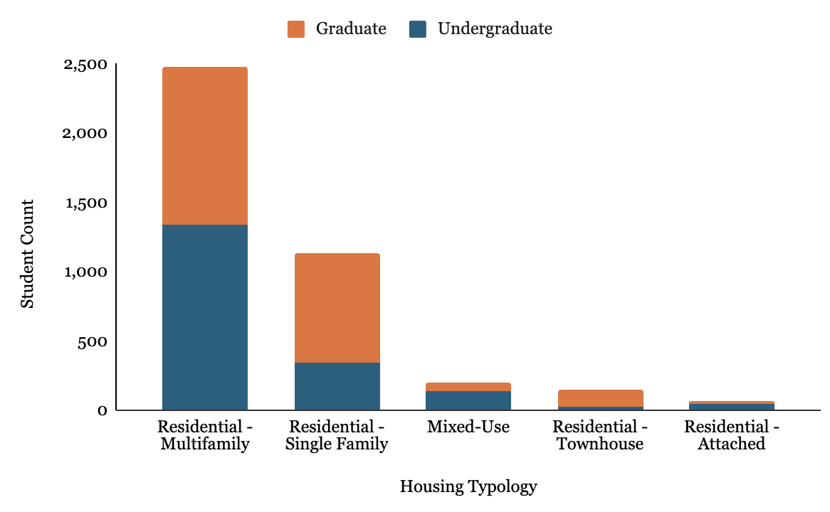
We analyzed 2025 local mailing addresses ¹ of students to investigate the living preferences of students. While UMD’s 42,439 students live across the region, 38% (16,172) live in College Park. Of those, 28% (4,505), live off campus, with approximately 53% of those students being graduates and 47% being undergraduates (2,388 and 2,117, respectively). Among off campus students in College Park, multifamily housing is dominant, with almost 72% of undergraduates and 54% of graduates living in multifamily buildings (Figure 5).

Figure 5: Housing Types for Graduate and Undergraduate Students Living in College Park. Source: NCSG Analysis of Registrar Office Data.
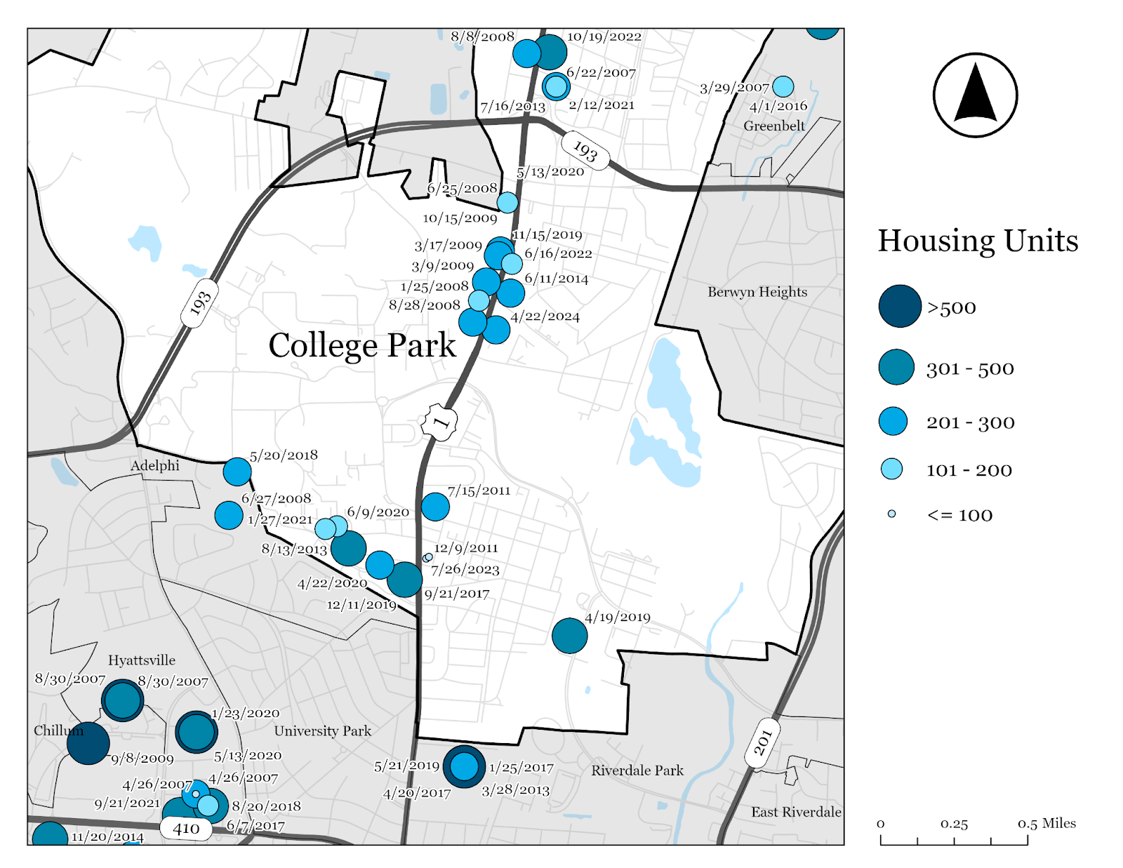
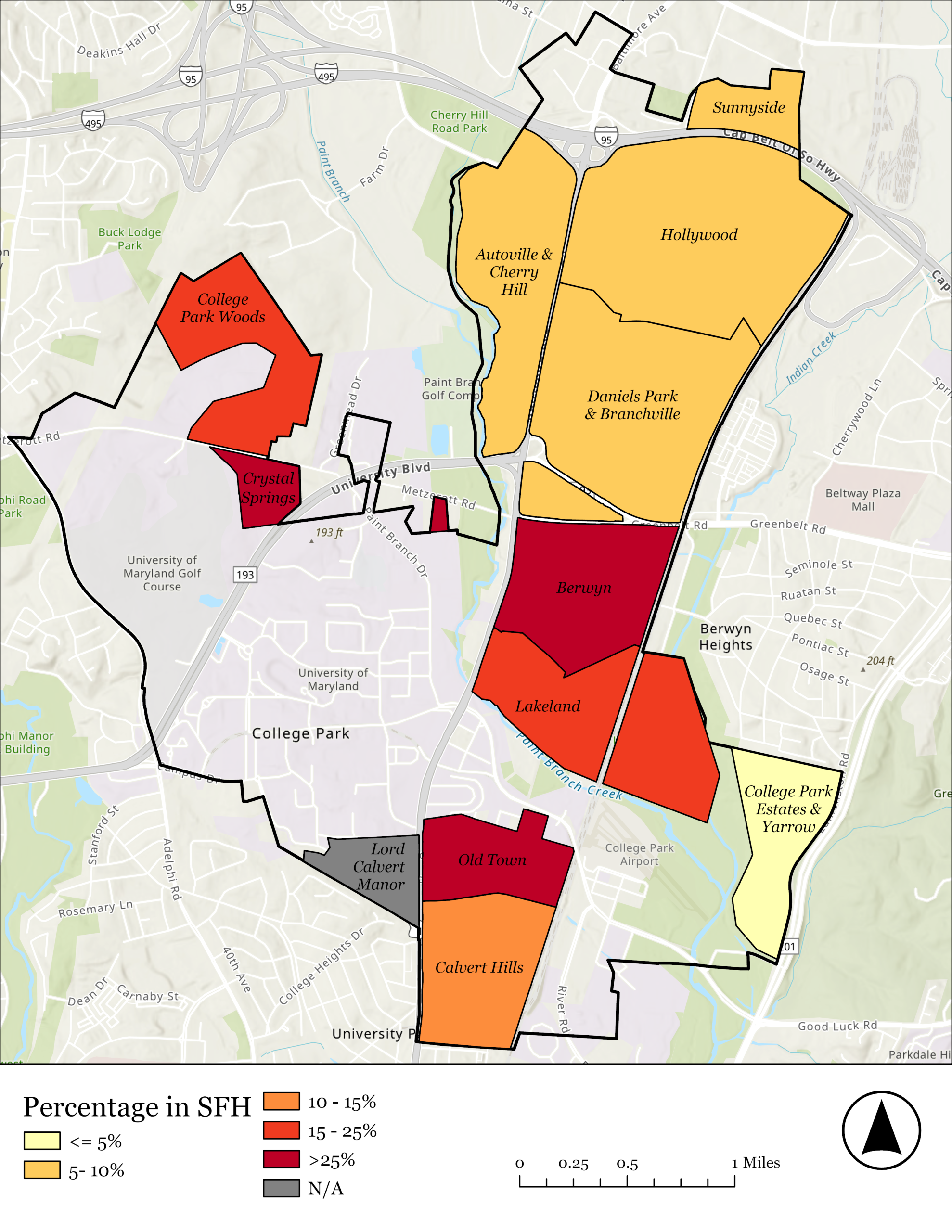
Further, we identified that just 13% of single-family homes had an associated student address. This figure falls to just 6% when we count only properties with multiple students in them, as while some students may be renting a singular room or ADU, others may be living with their parents or recording their address, and would therefore be the only student in that building. However, some neighborhoods have disproportionate shares of student-occupied single-family housing (Figure 6). 40% of the single-family homes in the Crystal Springs neighborhood are occupied by at least one student, while Berwyn and Old Town each have just under 30% of their single-family homes hosting at least one student. One home in Old Town was even identified as having 12 students.
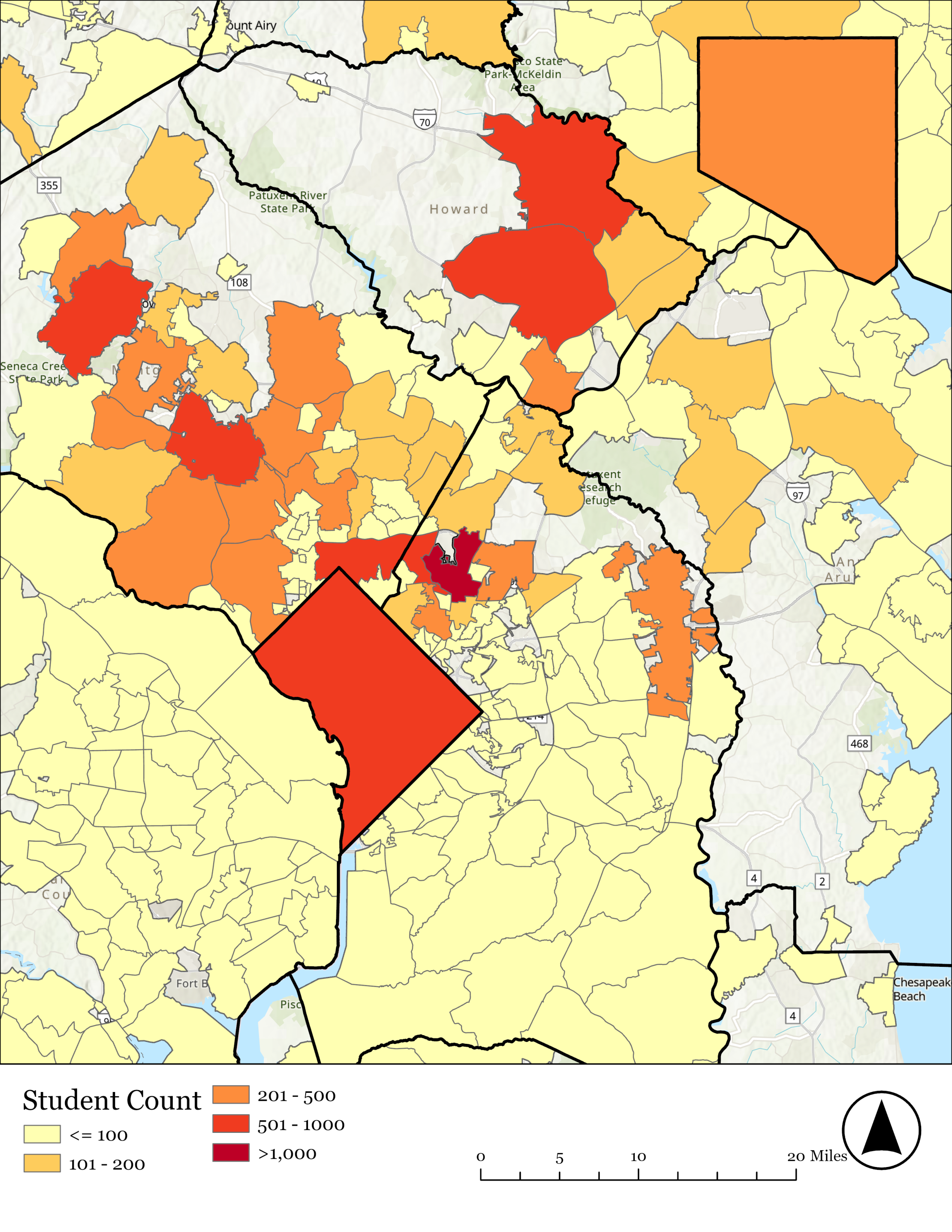
We then compared College Park with other cities and places across the region (Figure 7). Unsurprisingly, College Park hosts nearly half of all students with local addresses in Maryland, as nearly a third of the university lives on campus. Even after excluding those who live on campus, College Park is still home to more than 20% of all UMD students living in Maryland, more than the next 8 areas combined.

Figure 6: Percentage of Single-Family Homes Occupied by at least one student by Neighborhood in College Park. Source: NCSG Analysis of Registrar Office Data and City of College Park GIS data

Figure 7: Number of Students living in Census Designated Places in Maryland, 2025. Source: NCSG Analysis of Registrar Office Data and US Census Bureau data.
The contemporary era of studentification in College Park is intricately linked to the shift in enrollment at UMD (Figure 8). The university built housing alongside growth in the student population; there were 5,189 dorm beds constructed between 1960 and 1980, while there were no dorms constructed between 1990 and 2010. There was no need to construct dorms because undergraduate student enrollment saw a precipitous decline of 15.5% between 1980 and 2000. However, 2000 to 2010 saw an increase in students, both undergraduate and graduate. During this time period, census data records a substantial conversion of single-family homes into rental units, increasing from 648 renter-occupied single-family units in 2000 to 925 renter-occupied single-family units in 2010, and it has stayed around that level since.
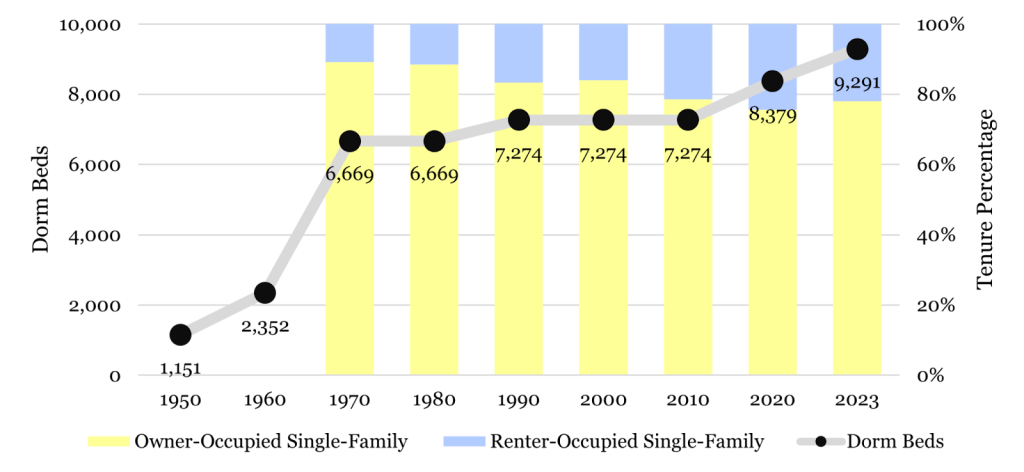
Figure 8: Single-Family Homes by Tenure and Total Dorm Beds. Source: IPUMS NHGIS & University of Maryland Residence Halls Page. Tenure data by housing typology is not available in College Park before 1970
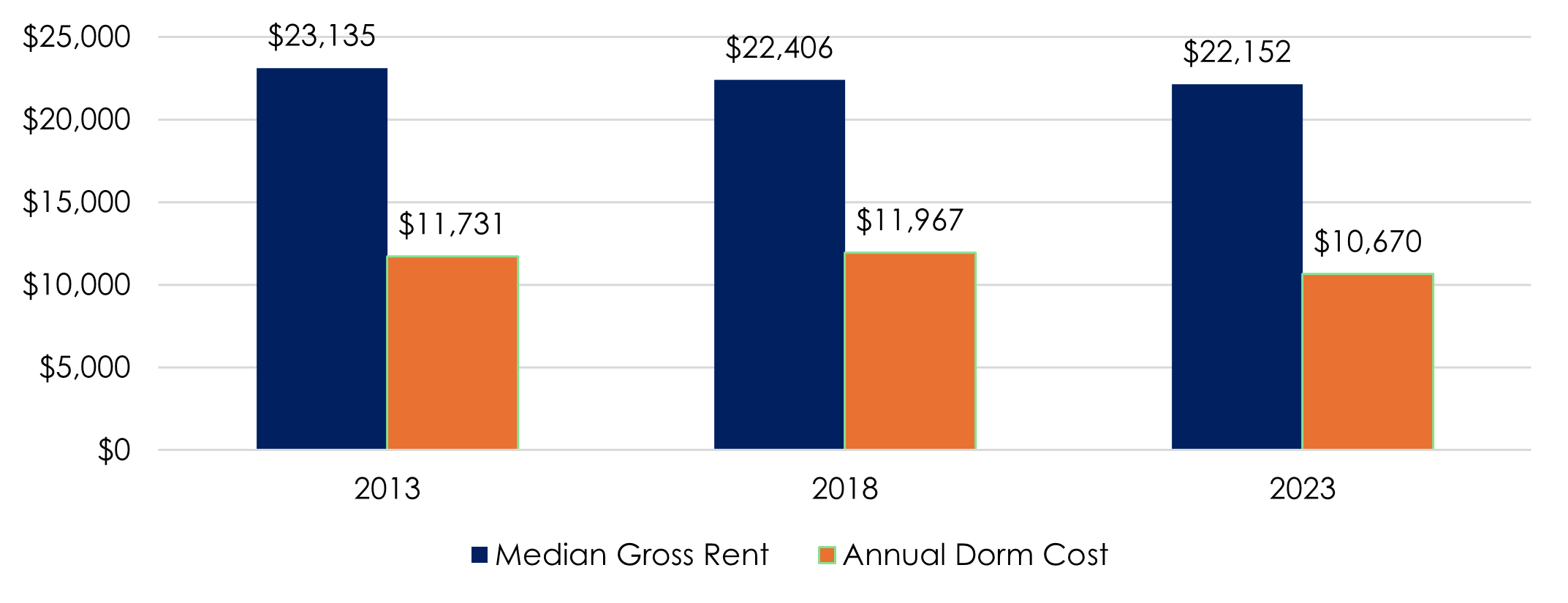
Finally, since 2010, the inflation adjusted median gross rent and annualized dorm cost in College Park have not increased. Figure 9 illustrates inflation-adjusted rents between 2013 and 2023. This reflects the impact of both the Central US Route 1 Plan, which facilitated 7,204 new apartments into the construction pipeline off campus, as well 2,000 new dorm beds on campus. Moreover, the construction of new apartments in nearby areas such as Hyattsville Crossing and Downtown Hyattsville have likely impacted the UMD housing market. At the same time, the number of renter occupied single-family homes in College Park did not increase outside the margin of error between 2010, 2020, or 2023. Our results indicate the demand for new housing near campus remains strong and is being met by increased construction, rather than the conversion of existing structures.
Discussion
The worst fears surrounding studentification in College Park: that new construction for students is driving up rental housing costs, while the students take over quiet single-family neighborhoods and opt out of multifamily living, is not supported by our analysis. City policy and partnership with UMD has successfully directed housing towards Route 1, intensifying development near campus and housing more students as a result, a clear case study of the studentification strategies described earlier. However, the trend of property owners converting their single-family homes into rental units represents a contemporary acceleration of studentification in College Park, particularly when enrollment increased from 2000 to 2010.
These strategies align with smart growth principles by preventing encroachment into surrounding neighborhoods where displacement risk is more acute. The efforts also created a more walkable and amenity-rich environment for students living in College Park. Furthermore, these findings provide limited evidence that dramatically increasing housing supply in near-campus neighborhoods can limit rent increases.
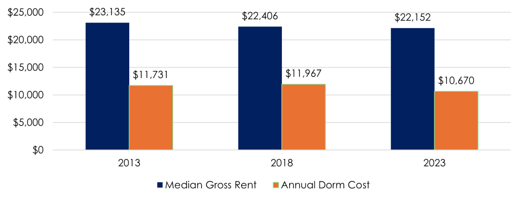
Figure 9: Inflation Adjusted Annualized Dorm Cost and Median Gross Rent. Source: IPUMS NHGIS & University of Maryland Common Data Set.
At the same time, students continue to live across the region. Certain areas near transit, such as Hyattsville and Silver Spring, are already important hubs of student housing, and these communities will be strengthened by the completion of the Purple Line. Others, such as East Riverdale and Langley Park, may be at particular risk of studentification given their current low student populations, relative affordability, and enhanced transit access to campus. In other words, the demand for housing near transit and with access to campus could create significant displacement risk for long-term and low- and moderate-income households living in those areas. Continued development of housing in areas where students already live is therefore necessary to preserve these communities and their diverse character.
Ultimately, we see these developments as proof that an intensification approach to studentification can realize city and university goals of building a “vibrant, diverse, and walkable community.” Planned future research will investigate how the construction of denser housing near campus impacts vehicle-miles travelled and multimodal transportation by students and College Park residents. Qualitative analysis will also shine light onto student attitudes towards both housing options and business preferences. Understanding ongoing commercial displacement of small businesses by mixed-use developments is another key area of future research, as these changes are a critical component of studentification. Finally, it will be important to continue this research following the construction of the Purple Line, to determine to what extent and where studentification and displacement occurs, and how it can be mitigated.
¹ We chose to investigate local addresses, as that is where students live during the academic year. This data is self-reported, meaning that there may be some students who misreport their address and put where their parents live, rather than where they live while classes are in session. Approximately 10% of students reported local addresses outside of the DMV.


